


Harry Cheselwoods
September 1, 2023
Share this post
Cloud cover is the single biggest driver of solar irradiance. So if you’re relying on data to plan, build, manage, or support solar power assets, you need to make sure the data is tracking the clouds well.
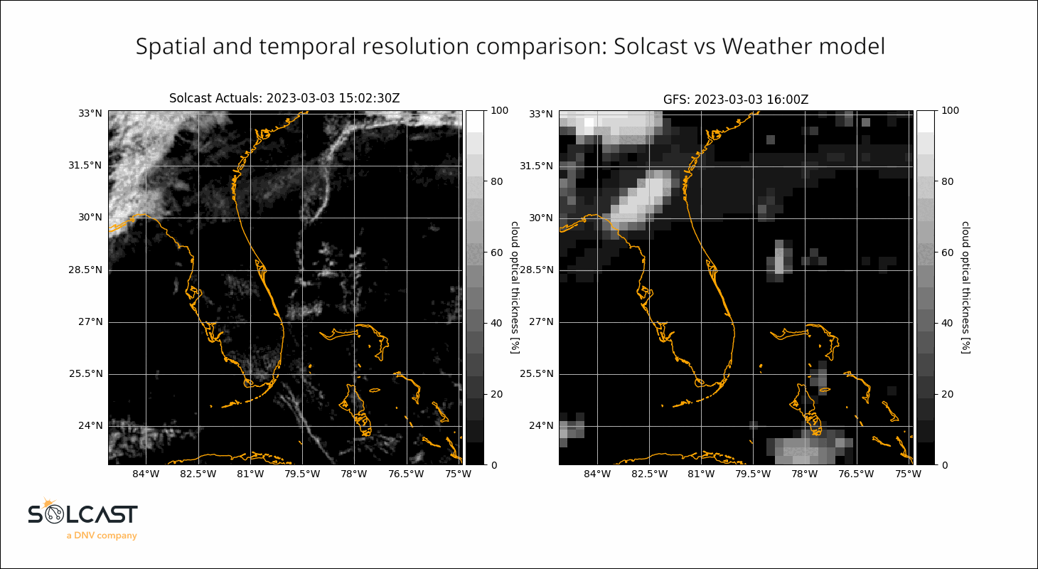
Generic weather data, like what you’ll get from most weather APIs, typically comes from forecasts and reanalyses of Numerical Weather Prediction (NWP) models, which operate at around 30km, hourly resolution. Solcast’s irradiance data and forecasts, provides data at a 1-2km and 5 minute resolution. Here’s what that difference looks like:
Delivering this level of accuracy is essential for solar developers, asset operators and managers, and grid or energy operators looking to understand how much power the assets they’re responsible for have, should have or will produce. And because Solcast data is used all over the world, and in every part of the solar and energy industries, it’s essential that we offer that data everywhere in the world, from 2007 up to 14 days into the future.
How to track clouds at high resolution:
Clouds develop, dissipate, move, and change rapidly, making tracking them accurately quite a challenge. Fortunately, since 2007, satellite technology has been able to provide the high-resolution imagery possible to track clouds at this level of detail. But it’s not just a matter of looking at satellite pictures. Solcast models ingest millions of data points to produce an understanding of how clouds are moving.
- Multiple Satellite Images: One image isn’t enough. By using multiple satellite images, at different wavelengths, and from the last few hours, Solcast models capture a fuller picture of the cloud movements, allowing for accurate tracking of cloud movement and development.
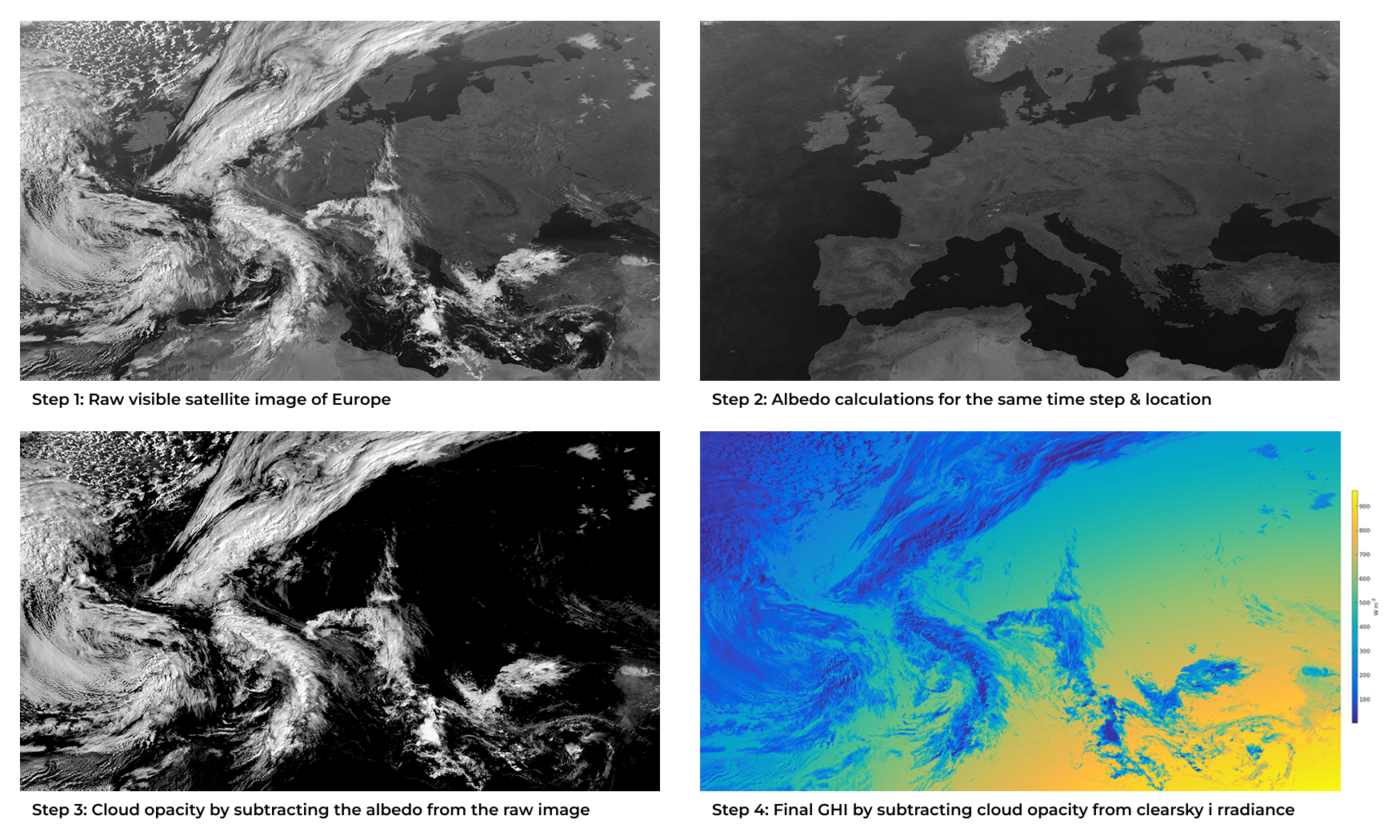
- Albedo: Separating cloud from the ground underneath it from a satellite image requires your models to have an understanding of what the ground underneath the cloud looks like. This is especially tricky in snowy or sandy regions, which have high and variable albedo! We use multiple sources for albedo, most recently adding new NASA MODIS satellite data.
- Machine Learning: Due to the global scale and low latency needed for high resolution cloud tracking, Solcast models use machine learning to quickly and accurately process and learn from recent data. Solcast deploys machine learning algorithms to determine cloud attributes like opacity and thickness.
5-minute Cloud Tracking
Solcast’s models advect cloud changes between satellite images, allowing us to create realistic cloud patterns between satellite images. Several regions globally don’t have 5 minute high resolution satellite imagery, especially for historic time periods, so to provide accurate and realistic 5 minute data our models must be able to consider the recent movements and local weather conditions to understand how and where clouds are going to change.
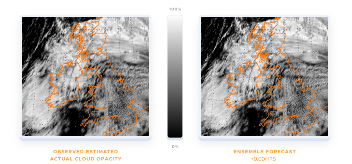
Even when we do have 5 minute cloud data, simply projecting forward current movement doesn’t accurately represent how clouds actually develop. Solcast’s modelling team have have built our models based on millions of high resolution satellite images, and actively model the recent cloud movement between satellite frames to understand how those trends will continue to develop. This, combined with a very low latency between satellite images and Solcast data processing, allows us to achieve very high levels of accuracy for our near term nowcasts.
The Importance & Benefits of Accurate Cloud Tracking:
Solcast clients are using high resolution data for:
- Improved Solar Power Forecasting: With accurate predictions, solar energy developers and operators can manage their assets more effectively. Regulatory forecasts often come with penalties for incorrect forecasting, and accurate cloud tracking can improve commercial outcomes through accurate forecasts and operational efficiencies. Large scale operators also use detailed forecasts to plan their operational activities to minimise losses, or make panel tracking decisions.
- Monitoring and Analytics: Commercial and Industrial assets below 2MW often don’t have pyranometers installed, and all pyranometers can be subject to faults, sensor drift and soiling. Remote satellite irradiance is often used to monitor assets remotely, verify and clean sensor data, and can be directly integrated into monitoring platforms to make this easier.
- Market and Grid Modelling: By aggregating cloud effects at high resolution over large areas, it’s possible to build models of behind-the-meter generation for residential rooftop solar, and generation from C&I and grid-scale solar assets. These insights are used by Grid Operators, TSOs, and ISOs to model supply and manage grid stability, and by energy traders and storage operators to model demand and prices in dynamic energy markets
- Resource Assessment: Detailed historical data, including sub-hourly data based on cloud tracking, allow for commercial modelling that captures the costs and impact of curtailment, inverter clipping, and other minute-to-minute impacts that are seen in sub-hourly historic data, but not well represented in P50 TMYs. Long term historical data is also useful for inter-annual variability modelling, and the impact of high resolution cloud tracking is seen in coastal and mountainous regions, where micro-climate effects can make differences at a scale below 10km.
- Financial Security: Precise solar irradiance forecasts and data allow operators to manage financial risks around curtailment, regulatory forecast penalties, asset downtime and production efficiency.
If your business could benefit from accurate irradiance data powered by high resolution cloud tracking, our team would love to discuss this with you. Connect with our team directly or get started on your evaluation by creating a commercial account in the Solcast Toolkit.