


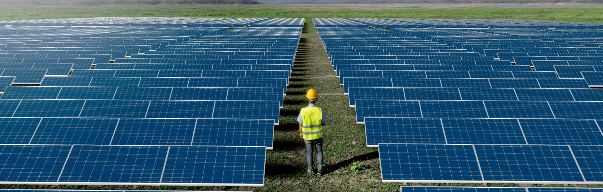
Typical Meteorological Year
Download a statistically representative “typical year” file built from 15 + years of satellite data for long-term yield modelling.
Solcast is independently validated as the lowest uncertainty solar resource dataset
Solargis is a Slovak company specialising in historical irradiance data, consulting, and increasingly in PV software. The company’s solar data was first developed around 2008 to 2011.
Solargis is a source of satellite-derived irradiance data.
Solcast and Solargis are the most extensively and independently validated global datasets available.
Solcast | Solargis | |
|---|---|---|
Free trial with instant access and data download? | ||
Comprehensive, global, independent validation | ||
Finest time resolution of satellite-based irradiance | 5 minutes | 15 minutes |
Real time data available? | ||
Updated October 2025
The Solargis and Solcast methodology is relatively similar. Both are semi-empirical and are satellite-derived. Both rely on validated, published models to build a clear sky model, and use proprietary cloud detection models. The input satellite imagery is similar, with Solargis using approx. 3-4km grids and Solcast using approx. 1-2km grids. Both datasets downscale solar irradiance parameters and can perform far horizon shading, Solcast to 90m and Solargis 250m. Solargis and Solcast both offer near-global data coverage (polar and remote ocean regions are excluded or have lower data quality). The Solargis database is compiled using high-resolution new satellites, and lower-resolution, pre-21st century satellites. Data coverage begins at 1994/1999/2006 depending on location. Solcast only uses data from recent generation geostationary meteorological satellites (GMS). We do not use data prior to 2007 due to climate change and satellite data quality issues. This maximises data quality and validity, while still providing 15+ years of data history from which to sample for interannual variability.
Solargis and Solcast are both extensively and independently validated, globally at 200+ sites. The differences in accuracy and uncertainty are small, with Solcast performing slightly better on GHI bias spread, GHI RMSE and DNI RMSE, and Solargis performing slightly better on DNI bias spread.
Solcast | Solargis (2025) | Solargis (2023) | |
|---|---|---|---|
Performed by | DNV | Solargis | IEA PVPS |
Year published | 2023 | 2025 | 2023 |
No. of sites | 207 | 320 | 119 |
Mean Bias | +0.33% | +0.5% | +0.07% |
Bias Std. Dev. | ±2.47% | ±3% | ±2.93% |
80% CI Bias (10% to 90%) | -2.84% to 3.50% | Not Published | -3.69% to +3.83% |
90% CI Bias (5% to 95%) | -3.74% to 4.40% | -4.0% to +5.9% | -4.76% to +4.90% |
Mean nMAD (nMAE) | 10.33% | Not Published | 9.03% |
Std. Dev. nMAD (nMAE) | ±3.72% | Not Published | ±2.86% |
Mean nRMSD (nRMSE) | 15.99% | 16.40% | 14.09% |
Std. Dev. nRMSD (nRMSE) | ±5.74% | Not Published | ±4.12% |
Updated Ocotber 2025
Solcast | Solargis (2025) | Solargis (2023) | |
|---|---|---|---|
Performed by | DNV | Solargis | IEA PVPS |
Year published | 2023 | 2025 | 2023 |
No. of sites | 117 | 235 | 119 |
Mean Bias | +1.50% | +2.2% | -0.42% |
Bias Std. Dev. | ±5.75% | ±6.0% | ±4.90% |
80% CI Bias (10% to 90%) | -5.87% to 8.86% | Not Published | -6.70% to +5.87% |
90% CI Bias (5% to 95%) | -7.96% to 10.95% | -7.2% to +11.1% | -8.48% to +7.65% |
Mean nMAD (nMAE) | 19.97% | Not Published | 18.66% |
Std. Dev. nMAD (nMAE) | ±5.94% | Not Published | ±5.08% |
Mean nRMSD (nRMSE) | 31.51% | 32.6% | 28.30% |
Std. Dev. nRMSD (nRMSE) | ±9.99% | Not Published | ±8.71% |
Updated October 2025
Solargis. (2025, February 17). Validation and uncertainty of solar resource data.
Solargis. (2019, November). Validation Report: Global Solar Atlas 2.0. World Bank - ESMAP.
Forstinger, A., et al. (2023). Worldwide benchmark of modelled solar irradiance data (2023 PVPS Task 16): Solar resource for high penetration and large-scale applications. ResearchGate.
Cuevas-Agulló, E., et al. (2023). A new global high-resolution solar resource dataset. Zenodo.

Download a statistically representative “typical year” file built from 15 + years of satellite data for long-term yield modelling.
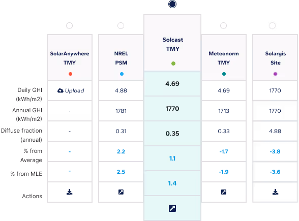
Compare multiple satellite data sets side-by-side to choose the most bankable resource file for your site.
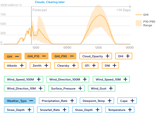
Access industry-leading solar forecasts up to 14 days ahead, combining satellite nowcasting and weather models for precision energy planning.
Subscribe to our newsletter to keep up to date with all the latest news.